Things To Do near Nattor Down
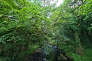
River Walkham, Dartmoor, Dartmoor National Park (approx. 3 miles away)
[Main photo: the River Walkham at Ward Bridge in the Walkham Valley] From high moor to the western border of Dartmoor National Park The River Walkham flows from remote, tussocky and boggy moorland on Dartmoor’s north moor through a heavily wooded valley to the western border of Dar...

Kitty Tor, Sourton, Dartmoor National Park (approx. 3 miles away)
One for the Dartmoor enthusiast or tor bagger, Kitty Tor is a collection of small outcrops on the high, flat moorland of Amicombe Hill, Woodcock Hill and Corn Ridge. Ten Tors teams nickname the valley east and north of Kitty Tor 'death valley'. The moorland surrounding Kitty Tor can get really boggy...

Gren Tor, Lydford, Dartmoor National Park (approx. 3 miles away)
Along with its neighbour Hunt Tor, Gren Tor is a small outcrop located on boggy moorland by the headwaters of the River Lyd. Like Hunt Tor, it's easily accessible from the Rattlebrook Peatworks Railway (Disused). We've positioned Gren Tor on Google maps so zoom in on the 'Satellite' setting to se...

King Way, Dartmoor, Dartmoor National Park (approx. 3 miles away)
In his work 'Walking Dartmoor's Ancient Tracks: A guide to 28 routes', Eric Hemery writes: 'In an attempt to account for the name-origin of the track, we must rely on both documented history and tradition concerning 'the King's Posts'. Although a regular postal service between the smaller towns o...

Cowsic Head, Princetown, Dartmoor National Park (approx. 4 miles away)
The River Cowsic is a short river that flows into the West Dart River at Two Bridges in the heart of Dartmoor National Park. The River Cowsic rises at Cowsic Head on a very boggy section of moorland on Dartmoor's north plateau. The Cowsic Head is close to Beardown Man Standing Stone and Devil's Tor....

Coombe Down, Lydford, Dartmoor National Park (approx. 4 miles away)
We include Coombe Down as a point of reference. The King Way and Rattlebrook Peatworks Railway (Disused) run across the down. It rises to Corn Ridge to the north east. To the north and north west it runs into Lake Down which drops down to Lake Viaduct. The Granite Way runs over the viaduct. A track...

Cut Lane (Cut Hill Peat Pass), Postbridge, Dartmoor National Park (approx. 4 miles away)
When describing Dartmoor's peat passes in his work 'High Dartmoor', Eric Hemery wrote: 'The most ancient, and in some way most intriguing, of these passes is Cut Lane (ref.). The link path from E. Dart country ascends to the water-divide and enters the pass through the fen, where the way is marke...

Cut Hill, Postbridge, Dartmoor National Park (approx. 4 miles away)
A visit to Cut Hill and nearby Fur Tor is a must for anyone with a passion for Dartmoor. This is the most remote area in southern England and it's a joy to visit so we'd very much recommend a day trip to the summit. Cut Hill, as the name suggests, is a dome of rough cut moorland in the heart...

Great Kneeset, Okehampton, Dartmoor National Park (approx. 4 miles away)
Great Kneeset is on the western edge of a large, boggy moorland plateau in the northern section of Dartmoor National Park. It's topped by granite outcrops and, for its location, is relatively easily accessible from the north via the army ring road and Dinger Tor. We've positioned Great Kneeset on...

Cut Hill Stone Row, Postbridge, Dartmoor National Park (approx. 4 miles away)
Many of Dartmoor's stone rows are difficult to miss. Huge blocks of granite rise from moorland creating impressive patterns in the landscape. Other stone rows are very difficult to find. Small granite teeth are covered by grass and lumpy moorland. The stone row on Cut Hill is something very differen...

Lyd Head, Lydford, Dartmoor National Park (approx. 4 miles away)
The River Lyd rises between Corn Ridge and Woodcock Hill in the north west section of Dartmoor National Park. It's boggy, flat terrain best avoided unless you're walking after a long period of dry weather. From its headwaters, the River Lyd flows past Great Nodden to the footbridge and stepping s...

Cut Hill North West Passage Peat Pass and Memorials, Postbridge, Dartmoor National Park (approx. 4 miles away)
Study Dartmoor's north plateau on the Ordnance Survey Explorer OL28 'Dartmoor' map and you'll see lots of peat passes marked by two thick, black parallel lines. These are paths cut through deep peat that covers the high moorland. On the ground, these peat passes vary quite dramatically. Some, lik...

Steng-a-Tor, Sourton, Dartmoor National Park (approx. 4 miles away)
Small outcrop above the south west wall of the Upper West Okement Valley. It's situated in a potentially very boggy part of Woodcock Hill and Corn Ridge. Walking up there after a period of heavy rain is an unpleasant experience. Sandy Ford crosses the West Okement River below. Ten Tors teams refer t...

Roos Tor, Merrivale, Dartmoor National Park (approx. 4 miles away)
Roos is the northernmost tor in a cluster of outcrops on the western side of Dartmoor National Park. It's near the stunning and much photographed Great Staple Tor and overlooks Langstone Moor with its stone circle, standing stone and stone row. Great Mis Tor dominates to the east. The view north alo...

Dartmoor Reptiles, Dartmoor, Dartmoor National Park (approx. 4 miles away)
Come and get up-close and personal with our 'unusual creatures’. We will tailor a one or two hour session especially for you so that your family can discover the magic and beauty of our collection of reptiles, spiders and other creepy crawlies. You will be able to learn about their natural habi...