Whitehorse Hill, Okehampton, Dartmoor National Park

High on Dartmoor's north plateau are a number of shallow domed hills. Unlike Yes Tor or Fur Tor, these hills are understated. They lack dramatic rocky outcrops and steep sides. However, many have distinctive features that tell fascinating stories about moorland life through history and prehistory. In addition, given their height, these hills offer spectacular views across Dartmoor and the Westcountry. Whitehorse Hill is one of the best.
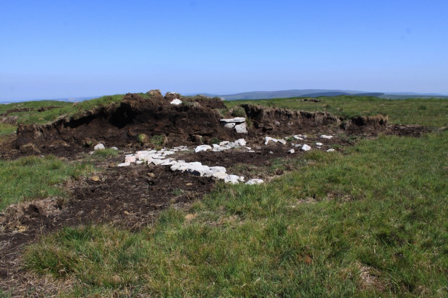
We've positioned Whitehorse Hill on Google maps so zoom in on the 'Satellite' setting to see its location. The hill is topped by the remarkable prehistoric burial chest Whitehorse Hill Cist. There's also a very impressive peat pass on the eastern flank of Whitehorse Hill.
Given its location on Dartmoor's high north plateau, you can walk in from many directions. Some, however, are difficult, especially after a spell of bad weather. This part of Dartmoor is characterised by its boggy, rough cut moorland which can be hard going.
Recommended route to Whitehorse Hill for the first time
To visit for the first time, we'd suggest walking in from Okehampton Camp or Belstone. Follow the army track up to Hangingstone Hill with its army hut. From there, and only in dry weather, you can bog hop south for about a kilometre to Whitehorse Hill. After wet weather, this direct route between Hangingstone Hill and Whitehorse Hill is unpleasant. Head for the peat pass to the east of Whitehorse Hill. This cuts back up the moor to the top of the hill. It's an astonishingly impressive peat pass. At the top is a memorial and by that is the cist.
Other possible routes to Whitehorse Hill
The following outlines other possible routes to Whitehorse Hill. They are summaries and not detailed route descriptions. We've walked them all whilst researching content for this site. Refer to the Ordnance Survey Explorer OL28 'Dartmoor' map or the Harvey British Mountain Map 'Dartmoor' map for detail.
Routes and directions to Whitehorse Hill from the east
From the east. You can walk in from Batworthy Corner near Kestor Rock above Chagford. If you choose this route, avoid Batworthy Mires. The safest route is to wander up to Scorhill Stone Circle and then north west towards Kennon Hill. You pick up a grass track that takes you to Hound Tor. There's a good track that climbs along a broad ridge to Hangingstone Hill and then Whitehorse Hill.
From Batworthy Corner, you can also walk in via Watern Tor by following the farm wall that cuts across the North Teign River by Manga Hole. There are iron railings to use to cross the water. You then follow the wall as it rises to Watern Tor. From there, very obvious tracks lead to Hangingstone Hill.
Last, you can wander in from Fernworthy. Head for Sittaford Tor and then follow the farm wall up to Quintin's Man and then across the moor to Whitehorse Hill.
Routes and directions to Whitehorse Hill from the west
From the west. You can walk to Whitehorse Hill from Cranmere Pool. You cross moorland between the sources of the River Taw and East Dart River. It can get very boggy on this stretch of the north plateau.
Routes and directions to Whitehorse Hill from the north
From the north. In addition to walking in via the army roads, you can yomp up to Cosdon Beacon and then wander down to Hound Tor. From there, you follow the aforementioned broad bridge to Hangingstone Hill.
Routes and directions to Whitehorse Hill from the south
From the south. From Postbridge, follow the East Dart River valley up to Sittaford Tor. As described above, you then follow the farm wall up to Quintin's Man and then across the moor to Whitehorse Hill.
After a spell of dry weather, when water levels are low, you can also cross the East Dart River at East Dart River Waterfall or upstream at Kit Rocks. Cross Statt's House Hill, jump across the skinny North Teign River close to its source and wander up to Quintin's Man.
Alternatively, follow the East Dart River from Postbridge to near its source. Yomp up to Whitehorse Hill. Note that this area is very boggy after wet weather. Great fun to do this when the moors are dried out, however.
See also Cut Hill which is about 4 kilometres south west of Whitehorse Hill as the crow flies. Walking between the two hills is tough going.
Photo Gallery