Harton Chest (Lustleigh Cleave), Lustleigh, Dartmoor National Park

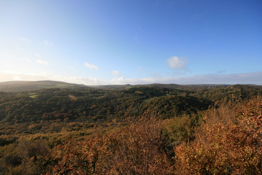
Harton Chest is a well known viewing point high up in Lustleigh Cleave. It's a collection of huge rocks that jut out of surrounding woodland. Exposed, there are big drops so this experience is not for those with a fear of heights. The Bovey Valley opens out far below. The views are huge and remarkable.
We've positioned Harton Chest on Google maps so zoom in on the 'Satellite' setting to see its location. To visit, we'd recommend starting from Hammerslake which is a tiny hamlet above Lustleigh village just up the road from the Dartmoor gateway town Bovey Tracey. If you look at the Ordnance Survey Explorer OL28 'Dartmoor' map, you'll see a path running from Hammerslake to Sharpitor. On the ground, it's a steep climb through woodland past massive chunks of moss covered granite to a broad ridge that runs along the top of Lustleigh Cleave. At Sharpitor, the path runs north west. You'll leave woodland, walk in to a big view of Lustleigh Cleave, Manaton and Hamel Down and then arrive at another patch of woodland. There, to your left, you'll see the collection of huge rocks that is Harton Chest. These are clearly visible on Google's satellite imagery.
Follow the path to the rocks. You have to clamber around the first cluster of boulders and then very carefully pick your way over other rocks to the edge of the outcrop. There are big, deep crevices between the rocks. After rain, when it's slippery, you have to be very careful. The view opens out over the Bovey Valley. You'll find yourself stood on flattish rocks below a particularly massive chunk of rock. For the full view, if it's dry, climb up onto this rock. It's very exposed, the drops are serious but the views are very special. Don't do this if you are at all scared of heights.
From the collection of rocks, you'll look down Lustleigh Cleave to the Bovey Valley Woodlands. Beyond that, on a clear day, you'll see the sea. Ahead of you are Trendlebere Down and Yarner Wood. The whole area forms the East Dartmoor National Nature Reserve. South and south west are Hound Tor, Hayne Down, Hamel Down and Easdon Tor. Manaton is the village scattered in the woodland. Autumn is particularly beautiful. If you can, go later in the day such that the sun is behind you and highlights the autumnal colours.
Be as careful picking your way back across the rocks as you were when you walked in.
There are various other viewpoints west of Harton Chest. See Lookout Rock (2) and then Lookout Rock (1). Beyond those are Raven's Tor and Hunter's Tor. The latter gives you a view of the north and north east of the Park.
Lustleigh Cleave and the Bovey Valley Woodlands are a maze of tracks. There are lots of other ways to get to Harton Chest described below. As ever, study the Ordnance Survey Explorer OL28 'Dartmoor' map before you go.
From Manaton. Head for Horsham and drop down the steep path to Horsham Steps to cross the River Bovey. Follow the track that rises diagonally through Lustleigh Cleave to Sharpitor and then walk across to Harton Chest. Note that there is a path that zig-zags directly to Harton Chest about half way up the diagonal track. You can also drop down to Foxworthy and either loop up to the broad ridge on the top of Lustleigh Cleave via Hunter's Tor or connect with the aforementioned diagonal track.
From Water and the Kestor Inn. Follow the very steep path down to Clam Bridge. Ascend to Sharpitor. Wander across to Harton Chest.
From Hisley, Pullabrook and the National Trust's Parke. You can wander up to Lustleigh Cleave from the bottom of the valley. Very well signposted paths climb to Sharpitor. An alternative route is to follow the River Bovey from Hisley Bridge to Clam Bridge. This path is clearly marked on the Ordnance Survey map.
Photo Gallery