Manaton to Horsham Steps and Lustleigh Cleave Circular Walk, Manaton, Dartmoor National Park

Crossing the River Bovey on huge boulders to explore Lustleigh Cleave
The River Bovey cuts a beautiful, steep-sided valley between the pretty village North Bovey and the Dartmoor gateway town Bovey Tracey.
This walk takes you to the upper section of the valley at Horsham Cleave, Lustleigh Cleave, Neadon Cleave and Water Cleave. You'll cross the river on a set of huge boulders known locally as Horsham Steps.
We outline two circular routes.
How far is it and how long will it take?
The walk is roughly 4 km/2.5 m in length if you chose the Foxworthy route.
The Ordnance Survey app states that this takes about 1 hr. We tend to cover a Dartmoor mile in 30 mins so plan for 1.15 hrs to enjoy the views and take photos.
The walk is roughly 6 km/4 m in length if you chose the Hammerslake and Lustleigh route.
The Ordnance Survey app states that this takes about 1.40 hrs. We tend to cover a Dartmoor mile in 30 mins so plan for 2 hrs to enjoy the views and take photos.
What's the walking like?
You're walking a steep-sided river valley so expect some steep descents and ascents.
Is there a path?
Yes, you're following paths by the River Bovey and in Horsham Cleave, Lustleigh Cleave, Neadon Cleave and Water Cleave.
Note that these cleaves are criss-crossed with paths used by local walkers. We'd recommend sticking to the paths outlined on the Ordnance Survey app or Explorer OL28 'Dartmoor' map on your first walk in the cleave.
Is it well signposted?
Yes and no. There are signposts by the River Bovey and in Horsham Cleave, Lustleigh Cleave, Neadon Cleave and Water Cleave but the area is heavily wooded so it's relatively easy to wander off the path.
We'd recommend referring to the Ordnance Survey app or Explorer OL28 'Dartmoor' map whilst reading this route description. Take a map and compass and check directions regularly.
Start from the car park in Manaton
Start from the car park in Manaton. This is located by the cricket pitch, church and village green.
Follow the road past Manaton St Winifred Church and the village green. Take the path on the right down to Horsham. This path is clearly marked on OS mapping.
You'll come to some cottages. To the left of the cottages is a path which runs down to the River Bovey and Horsham Steps. OS doesn't use the name Horsham Steps but on their mapping they are where the path crosses the river at Horsham Cleave and Neadon Cleave.
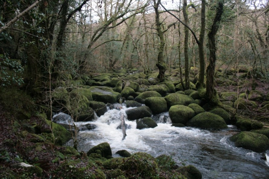
Horsham Steps
The steps crossing the River Bovey below Horsham are a natural collection of huge boulders on a bend in the river. They are known locally as Horsham Steps.
Cross the magnificent moss covered boulders to find a path which runs either left to Foxworthy or right to Hammerslake and Lustleigh.
Foxworthy
For the Foxworthy route, go past the pretty thatched houses in Foxworthy and follow the marked path through the woods and along a short stretch of lane until you meet another path on the left which takes you up hill and through several fields back to Manaton.
There are bluebells on this walk in spring.
Hammerslake and Lustleigh
For the Hammerslake and Lustleigh route, follow the path that climbs through Lustleigh Cleave in the direction of Hammerslake and Lustleigh.
You'll connect with another path that drops down to the River Bovey at Clam Bridge.
It's then a very steep climb to Water. Wander to the Kestor Inn if you fancy a pint.
From Water, take the path that runs through Letchole Plantation to Horsham and retrace your steps to the village green, church and car park from where you started in Manaton.
What should you do if the water level is high in the River Bovey?
Don't try to cross Horsham Steps if the water level is high in the River Bovey.
Instead, we'd recommend following the path through Neadon Cleave to Foxworthy Bridge. Cross the River Bovey here and head up into Lustleigh Cleave.
Follow the Hammerslake and Lustleigh route described above.
Photo Gallery